


PPM Commander - GPS status

Deskripsi PPM Commander - GPS status
Connect your external GPS device by USB or bluetooth. Route the GPS position as mock location provider to any navigation app on your phone or tablet.
Show GPS status data like position, height, accuracy, satellites, velocity, etc.
You can forward RTK correction data to your high accuracy external device. RTCM data is loaded from the internet by the internal NTRIP client.
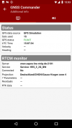
The app ist completely free with the exception of the NTRIP-RTCM feature. If you want to forward RTK data from your data provider (e.g. land surveying office) to the external GPS antenna, please license the app. You can fully test the NTRIP feature in advance within the 30 days trial period. You can view received RTCM message-types and coordinate-projection-parameters of the RTK data on the RTCM monitor page.
PPM Commander supports devices from ppm GmbH only, eg. ppm-10xx!
The PPM Commander can transform WGS84 coordinates into a local coordinate system like "Gauß-Krueger or UTM" for germany. Additionally you can set a fixed offset to the transformation for further improvement of the calculated local coordinate. If you allow mock locations in the developer options of your android device you can use the position of the external receiver in any application. The preferred way to process the external GPS position in other apps without using "mock locations" is implementing a simple ContentObserver. You can even get the transformed local coordinate and additional informations about the GPS status by using the app as content-provider.
By activating the "mocking" feature (get the position of your external GPS antenna into android) you can use this app for any other navigation-app or for geo-tagging.
Free features
+ GPS Status
+ Satellite list & Sky-Plot with subsystems like GPS, Glonass or Galileo
+ Coordinate-Transformation into local coordinate system
+ Mock location provider (e.g. use your external device for navigation)
+ Log all received NMEA data
You need a license for
+ RTK correction data over internet (NTRIP client)
+ RTCM monitor
+ Android "content provider" feature to access all status data
Hubungkan perangkat GPS eksternal Anda dengan USB atau bluetooth . Arahkan posisi GPS sebagai penyedia lokasi tiruan ke aplikasi navigasi apa pun di ponsel atau tablet Anda.
Tampilkan data status GPS seperti posisi, tinggi, akurasi, satelit, kecepatan, dll.
Anda dapat meneruskan data koreksi RTK ke perangkat eksternal akurasi tinggi Anda. Data RTCM diambil dari internet oleh klien NTRIP internal.
Aplikasi ini benar-benar gratis dengan pengecualian fitur NTRIP-RTCM. Jika Anda ingin meneruskan data RTK dari penyedia data Anda (mis. Kantor survei tanah) ke antena GPS eksternal, silakan lisensikan aplikasinya. Anda dapat sepenuhnya menguji fitur NTRIP terlebih dahulu dalam periode percobaan 30 hari. Anda dapat melihat jenis pesan RTCM yang diterima dan mengoordinasikan-proyeksi-parameter data RTK pada halaman monitor RTCM.
Komandan PPM hanya mendukung perangkat dari ppm GmbH, mis. ppm-10xx!
Komandan PPM dapat mengubah koordinat WGS84 menjadi sistem koordinat lokal seperti "Gauß-Krueger atau UTM" untuk Jerman. Selain itu Anda dapat menetapkan offset tetap pada transformasi untuk peningkatan lebih lanjut dari koordinat lokal yang dihitung. Jika Anda mengizinkan lokasi tiruan dalam opsi pengembang perangkat Android Anda, Anda dapat menggunakan posisi penerima eksternal dalam aplikasi apa pun. Cara yang disukai untuk memproses posisi GPS eksternal di aplikasi lain tanpa menggunakan "lokasi palsu" adalah menerapkan ContentObserver sederhana. Anda bahkan bisa mendapatkan koordinat lokal yang diubah dan informasi tambahan tentang status GPS dengan menggunakan aplikasi sebagai penyedia konten.
Dengan mengaktifkan fitur "mengejek" (dapatkan posisi antena GPS eksternal Anda menjadi android) Anda dapat menggunakan aplikasi ini untuk aplikasi navigasi lain atau untuk penandaan geografis.
Fitur gratis
+ Status GPS
+ Daftar satelit & Sky-Plot dengan subsistem seperti GPS, Glonass atau Galileo
+ Koordinat-Transformasi ke dalam sistem koordinat lokal
+ Penyedia lokasi mock (mis. Gunakan perangkat eksternal Anda untuk navigasi)
+ Log semua data NMEA yang diterima
Anda memerlukan lisensi untuk
+ Data koreksi RTK melalui internet (klien NTRIP)
+ Monitor RTCM
+ Fitur "penyedia konten" Android untuk mengakses semua data status
PPM Commander - GPS status - Versi 2.8.2.3
(13-06-2021)
PPM Commander - GPS status - Informasi APK
Versi APK: 2.8.2.3Paket: de.pilablu.gnsscommanderVersi Terakhir dari PPM Commander - GPS status
Versi lain


Aplikasi pada kategori yang sama

Anda juga mungkin suka...
Aplikasi pada kategori yang sama


